EVERY day, millions of people rely on satellites without giving them a second thought.
When motorists follow directions on their smartphones, pilots navigate aircraft across continents, fishermen check weather conditions before heading out to sea or families receive advance warnings about approaching storms, satellite technology is quietly working in the background.
It has become so deeply embedded in modern life that most people rarely stop to consider how much they depend on it.
Yet despite their growing importance, satellites continue to be viewed by many as symbols of scientific achievement rather than practical tools that influence everyday decision-making.
For decades, success in space was measured by how many rockets a country launched or how many astronauts it sent into orbit.
Today, however, the conversation has shifted dramatically.
Around the world, governments and private companies are investing in satellites not simply because they want to reach space, but because of what space technology can reveal about the Earth below.
Increasingly, experts say the greatest value lies not in the hardware orbiting hundreds of kilometres above the planet, but in the enormous amount of information those satellites continuously collect and transmit back to Earth.
From monitoring forests and predicting floods to tracking greenhouse gas emissions, improving agricultural productivity, managing maritime traffic and supporting urban planning, satellite-derived information has become an increasingly valuable resource underpinning industries that extend far beyond aerospace itself.
This transformation has fundamentally reshaped what was once considered the traditional space industry into what many experts now describe as the New Space Economy.
While rockets, launch vehicles and satellites remain essential infrastructure, much of the industry’s commercial value is increasingly generated by downstream services that analyse, interpret and apply space-based information to solve real-world problems.
In many ways, satellites have become sophisticated data collection platforms.
The real product is no longer the satellite itself, it is the information.
For Sarawak, where economic development remains closely linked to natural resources, renewable energy, environmental conservation and digital transformation, that distinction could prove particularly significant.
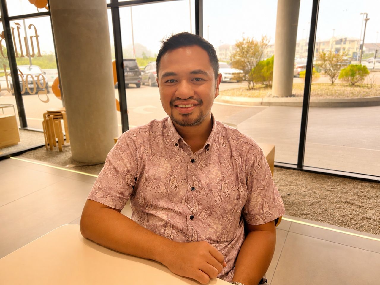
Deputy Dean of the Faculty of Aerospace Engineering and senior lecturer at iCATS University College, Abdul Qaiyum Alidin, believes misunderstanding this concept remains one of the biggest misconceptions surrounding satellite technology.
He said many people continue to associate satellites almost exclusively with taking photographs from space.
In reality, modern satellites are capable of collecting vast amounts of information using specialised sensors that observe changes across the Earth’s surface, atmosphere and oceans with remarkable precision.
“The satellite itself is not the final product.
The real value comes from the data and that is what creates the New Space Economy,” he stressed.
Abdul Qaiyum noted that launching a satellite may capture public attention, but the long-term economic opportunities emerge only when the information collected is translated into practical applications capable of improving industries, supporting policymaking and creating commercial value.
“If we only think about launching satellites, we miss the bigger picture.
The real opportunity comes afterwards,” he said.
That philosophy explains why countries are no longer measuring success solely by the number of satellites they place into orbit.
Instead, increasing emphasis is being placed on what those satellites can observe, how frequently they can collect information and how effectively governments, businesses and researchers are able to transform that information into solutions.
It also explains why many countries are increasingly deploying constellations of smaller satellites instead of relying upon a single large spacecraft.
Rather than waiting days or weeks for one satellite to revisit the same location, multiple satellites working together can monitor the Earth’s surface much more frequently, allowing environmental changes, weather systems and land conditions to be observed almost in real time.
This continuous stream of information has become one of the defining characteristics of the New Space Economy.
For Sarawak, Abdul Qaiyum believes one of the greatest opportunities lies in environmental management.
Home to one of the largest remaining tropical rainforest ecosystems in Southeast Asia, Sarawak’s forests are increasingly recognised not only for their ecological importance but also for their growing economic value within global carbon markets.
“As international demand increases for verified carbon credits and sustainable resource management, accurately measuring, monitoring and reporting changes within forest ecosystems has become more important than ever,” he said.
Abdul Qaiyum pointed out that satellite technology is expected to play an increasingly important role in what is known as Measurement, Reporting and Verification (MRV), the internationally recognised framework used to assess and verify carbon stored within forests.
Without reliable and independently verifiable information, carbon markets cannot function effectively.
“Satellites enable large areas of forest to be monitored consistently over time, complementing field observations while providing decision-makers with a clearer understanding of environmental changes.
“As Sarawak continues positioning itself as a leader in renewable energy and carbon management, these capabilities could become increasingly valuable in supporting environmental governance and international reporting requirements,” he said.
Unlike traditional field surveys that require extensive manpower and significant time to cover large areas, satellite observations allow researchers to examine forest conditions repeatedly over extended periods.
Changes in vegetation cover, land use and forest degradation can be monitored far more efficiently, helping authorities identify trends that may otherwise take months to detect.
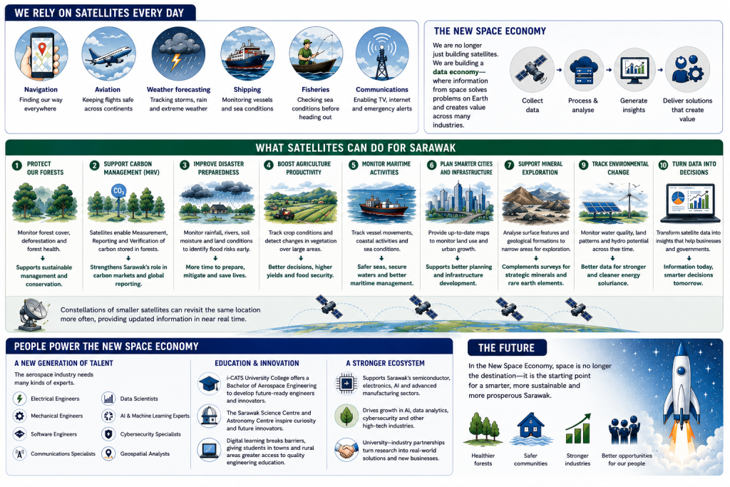
This image is generated by ChatGPT and intended for educational and illustrative purposes only. It does not depict real individuals or actual events.
For a state as geographically vast as Sarawak, where many forested areas remain remote and difficult to access, these capabilities could significantly strengthen environmental monitoring while supporting more informed policy decisions.
While environmental conservation is among the most visible applications of satellite technology, Abdul Qaiyum said its potential extends far beyond protecting forests.
For Sarawak, where rivers remain central to many communities and seasonal flooding continues to affect thousands of residents each year, satellite-derived information could become an increasingly valuable tool in disaster preparedness.
He noted that flooding remains one of the most frequent natural disasters affecting communities throughout the state, with climate change making rainfall patterns increasingly difficult to predict.
“Although weather forecasting has improved significantly over the past decade, emergency responses are often initiated only after rivers begin overflowing or communities have already been inundated.
Satellite observations offer another layer of information that can strengthen preparedness long before floodwaters begin rising,” he said.
By continuously monitoring rainfall distribution, vegetation cover, river catchments, soil moisture and changes in land surface conditions, satellites allow scientists to observe how landscapes respond over time.
Rather than providing a single snapshot, they generate continuous datasets that help identify trends, detect anomalies and improve understanding of areas that may be vulnerable to flooding.
For authorities, that additional information could support more informed planning and mitigation efforts.
Instead of reacting only after disasters occur, satellite-derived data may help agencies identify vulnerable locations earlier, improve resource allocation and strengthen emergency preparedness.
Beyond disaster management, Abdul Qaiyum shared satellite technology has applications across almost every sector considered strategically important to Sarawak’s future development.
In agriculture, Earth observation satellites can monitor changes in vegetation over extensive areas, providing farmers, researchers and policymakers with information that helps them better understand crop conditions and identify changes that may require closer attention.
Although satellites cannot replace on-the-ground inspections, they provide a broader perspective that would otherwise require considerable time, manpower and financial resources to obtain.
Similarly, in forestry, satellite imagery enables long-term monitoring of land cover, forest health and changes within protected areas.
Such information supports sustainable forest management while complementing conventional field surveys.
For a state that continues positioning itself as a leader in renewable energy, biodiversity conservation and carbon management, maintaining accurate environmental information has become increasingly important.
Satellite technology is also expected to play an expanding role within Sarawak’s maritime sector.
With one of Malaysia’s longest coastlines and busy shipping routes serving ports such as Kuching, Tanjung Manis, Bintulu and Miri, satellite systems can assist authorities in monitoring vessel movements, coastal activities and changing marine conditions.
For urban planners, satellite mapping provides updated geospatial information that allows planners to monitor land use, infrastructure expansion and patterns of urban growth more efficiently than traditional mapping methods alone.
Rapidly developing areas can therefore be observed more regularly, providing governments with additional information to support long-term planning.
Abdul Qaiyum also pointed to the technology’s growing importance in geological studies.
While satellites cannot directly detect underground mineral deposits, they are capable of analysing surface characteristics, geological formations and subtle variations in terrain that help researchers narrow areas requiring further investigation.
“As Sarawak continues exploring opportunities in strategic minerals and rare earth elements, such information could complement conventional geological surveys,” he said.
Collectively, these examples illustrate how dramatically the conversation surrounding satellites has evolved over the past decade.
Once regarded primarily as scientific instruments or symbols of national prestige, satellites are now increasingly recognised as platforms supporting a wide range of economic activities on Earth.
For Abdul Qaiyum, that represents the most significant shift within the New Space Economy.
He said success is no longer determined simply by how many satellites a country launches into orbit.
“Instead, increasing attention is being placed on how effectively governments, businesses and researchers transform satellite-derived information into products, services and solutions that create tangible economic and social value,” he said.
However, Abdul Qaiyum pointed out that technology alone will not transform Sarawak.
He said satellites can collect enormous volumes of information every day but without people capable of interpreting that information, designing new technologies and developing practical applications, much of their potential will remain unrealised.
“The technology can be purchased, but knowledge has to be developed.
That is why education is so important,” he said.
Abdul Qaiyum cited every satellite represents the combined expertise of professionals working across numerous disciplines.
Contrary to popular perception, he said careers within the aerospace sector are no longer limited to astronauts or pilots.
Instead, the modern space industry depends upon multidisciplinary teams bringing together expertise in engineering, electronics, telecommunications, robotics, computer science, artificial intelligence and data analytics.
“You don’t have to become an astronaut to work in space technology.
The aerospace industry needs people from many different backgrounds,” he said.
Recognising these changing workforce requirements, iCATS University College introduced its Bachelor of Aerospace Engineering programme to prepare students for careers in one of the world’s fastest-growing technology sectors.
For Abdul Qaiyum, universities play a role that extends far beyond producing graduates.
“Universities are where research begins, ideas are tested, industry partnerships are formed and future technologies are developed.
Our responsibility is not only to produce graduates but to also produce innovators,” he said.
Rather than viewing aerospace as a standalone industry, Abdul Qaiyum asserted it should be seen as one that complements and strengthens capabilities Sarawak is already developing.
He explained modern satellites are essentially sophisticated electronic systems comprising semiconductor chips, sensors, communication technologies, on-board computers and advanced software.
“Many of the technical capabilities required to support the aerospace industry therefore already exist within Sarawak’s growing semiconductor and electronics ecosystem.
Instead of building an entirely new industry from the ground up, Sarawak has an opportunity to build upon these existing strengths while creating new pathways for research, innovation and high-value employment,” he said.
Contrary to popular belief, Abdul Qaiyum reckoned Sarawak does not need to manufacture rockets before participating in the New Space Economy.
Instead, the state can begin by developing expertise in areas where it already possesses competitive advantages, including advanced manufacturing, embedded systems, software development, geospatial analysis and satellite applications.
These are the areas where much of the industry’s future growth is expected to occur.
Abdul Qaiyum also welcomed the development of the Sarawak Science Centre and Astronomy Centre.
Describing both as important long-term investments in cultivating interest in science, technology, engineering and mathematics (STEM) among young Sarawakians, he said exposure plays a crucial role in shaping career aspirations.
“Children who have opportunities to explore astronomy, robotics, engineering and space science through interactive learning are more likely to develop curiosity about careers they may never previously have considered.
Creating that early exposure is just as important as building laboratories or launching satellites because it inspires the next generation of scientists, engineers and innovators who will eventually lead the industry,” he stressed.
At the same time, advances in digital technology are also making specialised education more accessible than ever before.
As online learning platforms continue to improve and internet connectivity expands throughout Sarawak, students living outside the state’s major urban centres are finding it easier to access engineering education and technical training.
While laboratory work remains an essential component of aerospace engineering, much of the theoretical learning can now be delivered remotely, allowing students from rural communities to participate without immediately relocating.
Looking ahead, Abdul Qaiyum expects artificial intelligence to become one of the defining technologies shaping the future of aerospace.
As thousands of satellites continue to orbit Earth, he said future spacecraft will increasingly rely on artificial intelligence to process information on-board, optimise operations and respond autonomously to changing conditions.
“Rather than transmitting every piece of raw data back to Earth, satellites will be capable of analysing information in orbit before sending only the most relevant insights to ground stations.
This will allow faster decision-making while reducing communication demands and operational costs,” he added.
Abdul Qaiyum said artificial intelligence is also expected to play a growing role in image analysis, collision avoidance, predictive maintenance and the management of satellite constellations.
“The next generation of satellites will be much smarter than today’s, and artificial intelligence will become an integral part of space technology,” he said.
For Sarawak, this evolution creates opportunities extending well beyond aerospace engineering itself.
Future demand is expected to grow not only for aerospace engineers but also for software developers, artificial intelligence specialists, cybersecurity professionals, environmental scientists, geospatial analysts and data engineers capable of transforming satellite-derived information into practical solutions.
In many respects, that reflects the true nature of the New Space Economy.
It is not simply creating another engineering discipline as it is creating an ecosystem where science, technology, research, entrepreneurship and innovation converge.
As such, Sarawak’s proposed nano satellite should therefore be viewed not simply as another technological milestone but as the beginning of a broader journey towards building an innovation-driven economy where data, knowledge and human capital become just as valuable as the state’s abundant natural resources.
If realised, the satellite will represent more than an achievement in engineering.
It will symbolise Sarawak’s ambition to participate in one of the defining technological transformations of the 21st century – not by competing with established space powers, but by applying space technology to improve environmental management, strengthen disaster resilience, support sustainable development and create new opportunities for future generations.
In the New Space Economy, the greatest opportunities are no longer found hundreds of kilometres above the Earth.
They are found in how the knowledge and information returned from space can help improve life here at home.