KUCHING: Five areas in Sarawak recorded unhealthy Air Pollution Index (API) readings as of 2pm today (Aug 24), amid worsening haze conditions across parts of the country.
Department of Environment (DOE) deputy director-general Azuri Azizah Saedon said 29 areas nationwide were recording unhealthy API readings, with several areas in Sarawak among those affected.
In Sarawak, Serian recorded the highest reading at 182, followed by Sri Aman (170), Kuching (160), Samarahan (156) and Sarikei (153).
“The air quality in the country today was found to have deteriorated, with an increase in areas recording unhealthy API readings in the states along the west coast of Peninsular Malaysia and several areas in Sarawak, caused by the movement of haze from various directions.
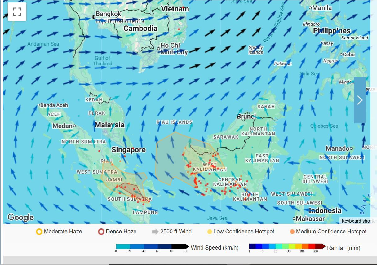
Azuri said the ASEAN Specialised Meteorological Centre (ASMC), based in Singapore, had detected 287 hotspots in Kalimantan, 65 in Sumatra and 11 in Malaysia based on National Oceanic and Atmospheric Administration (NOAA) 20 satellite imagery.
Of the hotspots detected in Malaysia, eight were in Sarawak, two in Johor and one in Selangor.
She said the ASMC Regional Haze Map showed persistent dry weather across most of the southern ASEAN region, although rainfall was occurring mainly over northern Borneo and Sumatra, as well as several areas in Peninsular Malaysia.
The department also noted scattered hotspots mainly in parts of Kalimantan and southern and central Sumatra.
Moderate to dense transboundary haze was observed over West Kalimantan and moving northwards towards western Sarawak.
Several air quality monitoring stations in West Kalimantan, western Sarawak, western Peninsular Malaysia, as well as southern and central Sumatra recorded air quality levels ranging from unhealthy to very unhealthy.
The actual condition of hotspots and haze in the region could not be fully determined due to cloud cover.
DOE has stepped up enforcement actions and daily patrol activities in areas with potential open burning activities, as well as monitored the API readings from time to time.
The National Open Burning Action Plan and National Haze Action Plan have been activated to coordinate Government agency actions in addressing open burning issues and dealing with the country’s haze situation.
All landowners are advised to closely monitor areas prone to and frequently affected by fires such as landfills, forests, peatlands, plantations, agricultural, and industrial sites, and to take preventive measures against trespassing by irresponsible parties that could lead to open burning, whether intentional or accidental.